Earth
ID: 4628
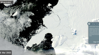
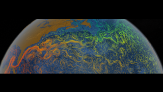
Sea ice in the Arctic grew to its annual maximum extent on March 17, 2018, joining 2015, 2016, and 2017 as the years with the lowest maximum extents on record, according to scientists at the National Snow and Ice Data Center (NSIDC) and NASA. The Arctic sea ice cover peaked at 5.59 million square miles (14.48 million square kilometers), making it the second lowest maximum on record, at about 23,000 square miles (60,000 square kilometers) higher than the record low maximum reached on March 7, 2017.
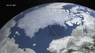
This animation runs from October 1, 2017 to March 17, 2018, the date that the maximum sea ice extent occurred. The images shown here portray the sea ice as it was observed by the AMSR2 instrument onboard the Japanese Shizuku satellite. The opacity of the sea ice shown in this animation is derived from the AMSR2 sea ice concentration. The blueish white color shown on the sea ice is derived from the AMSR2 89 GHz brightness temperature data.
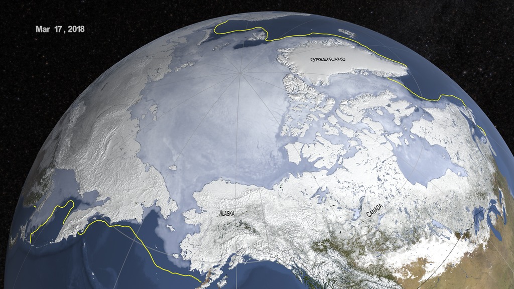


Sea Ice Maximum extent 2018
This animation runs from October 1, 2017 to March 17, 2018, the date that the maximum sea ice extent occurred. The images shown here portray the sea ice as it was observed by the AMSR2 instrument onboard the Japanese Shizuku satellite. The opacity of the sea ice shown in this animation is derived from the AMSR2 sea ice concentration. The blueish white color shown on the sea ice is derived from the AMSR2 89 GHz brightness temperature data.
Used Elsewhere In
Visualization Credits
Lead Visualizer:
Cindy Starr (Global Science and Technology, Inc.)
Lead Producer:
Kathryn Mersmann (USRA)
Technical Support:
Laurence Schuler (ADNET Systems, Inc.)
Ian Jones (ADNET Systems, Inc.)
Project Support:
Joycelyn Thomson Jones (NASA/GSFC)
Leann Johnson (Global Science and Technology, Inc.)
Eric Sokolowsky (Global Science and Technology, Inc.)
Please give credit for this item to:
NASA's Scientific Visualization Studio
The Blue Marble data is courtesy of Reto Stockli (NASA/GSFC).
NASA's Scientific Visualization Studio
The Blue Marble data is courtesy of Reto Stockli (NASA/GSFC).
Short URL to share this page:
https://svs.gsfc.nasa.gov/4628
Data Used:
Note: While we identify the data sets used in these visualizations, we do not store any further details nor the data sets themselves on our site.
Keywords:
DLESE >> Cryology
SVS >> HDTV
GCMD >> Earth Science >> Cryosphere >> Sea Ice >> Sea Ice Concentration
GCMD >> Earth Science >> Cryosphere >> Sea Ice >> Sea Ice Motion
GCMD >> Earth Science >> Oceans >> Sea Ice >> Sea Ice Concentration
GCMD >> Earth Science >> Oceans >> Sea Ice >> Sea Ice Motion
SVS >> Hyperwall
SVS >> Sea ice Motion
NASA Science >> Earth
GCMD >> Earth Science >> Climate Indicators >> Cryospheric Indicators >> Sea Ice Concentration
GCMD keywords can be found on the Internet with the following citation: Olsen, L.M., G. Major, K. Shein, J. Scialdone, S. Ritz, T. Stevens, M. Morahan, A. Aleman, R. Vogel, S. Leicester, H. Weir, M. Meaux, S. Grebas, C.Solomon, M. Holland, T. Northcutt, R. A. Restrepo, R. Bilodeau, 2013. NASA/Global Change Master Directory (GCMD) Earth Science Keywords. Version 8.0.0.0.0
https://svs.gsfc.nasa.gov/4628
Data Used:
GTOPO30 Topography and Bathymetry
Data Compilation - USGSTerra and Aqua/MODIS/Blue Marble: Next Generation also referred to as: BMNG
1994
Credit:
The Blue Marble data is courtesy of Reto Stockli (NASA/GSFC).
The Blue Marble data is courtesy of Reto Stockli (NASA/GSFC).
SHIZUKU (GCOM-W1)/AMSR2/10 km Daily Sea Ice Concentration
Observed Data - Japan Aerospace Exploration Agency - Oct. 1, 2017 - Mar 4. 2018
Credit:
AMSR2 data courtesy of the Japan Aerospace Exploration Agency (JAXA).
AMSR2 data courtesy of the Japan Aerospace Exploration Agency (JAXA).
SHIZUKU (GCOM-W1)/AMSR2/10 km Daily 89 GHz Brightness Temperature
Observed Data - Japan Aerospace Exploration Agency - Oct. 1, 2017 - Mar 4. 2018
Credit:
AMSR2 data courtesy of the Japan Aerospace Exploration Agency (JAXA).
AMSR2 data courtesy of the Japan Aerospace Exploration Agency (JAXA).
Greenland Mass Conservation Dataset - Surface Elevation
Data Compilation - Ice Sheet Modeling Group, UC, Irvine - 1993 - 2013Keywords:
DLESE >> Cryology
SVS >> HDTV
GCMD >> Earth Science >> Cryosphere >> Sea Ice >> Sea Ice Concentration
GCMD >> Earth Science >> Cryosphere >> Sea Ice >> Sea Ice Motion
GCMD >> Earth Science >> Oceans >> Sea Ice >> Sea Ice Concentration
GCMD >> Earth Science >> Oceans >> Sea Ice >> Sea Ice Motion
SVS >> Hyperwall
SVS >> Sea ice Motion
NASA Science >> Earth
GCMD >> Earth Science >> Climate Indicators >> Cryospheric Indicators >> Sea Ice Concentration
GCMD keywords can be found on the Internet with the following citation: Olsen, L.M., G. Major, K. Shein, J. Scialdone, S. Ritz, T. Stevens, M. Morahan, A. Aleman, R. Vogel, S. Leicester, H. Weir, M. Meaux, S. Grebas, C.Solomon, M. Holland, T. Northcutt, R. A. Restrepo, R. Bilodeau, 2013. NASA/Global Change Master Directory (GCMD) Earth Science Keywords. Version 8.0.0.0.0