FIRST GLOBAL 3-D VIEW OF MARS REVEALS DEEP BASIN AND PATHWAYS
FOR WATER FLOWAn impact basin deep enough to swallow Mount Everest and surprising
slopes in Valles Marineris highlight a global map of Mars that will influence scientific
understanding of the red planet for years.
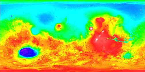
Generated by the Mars Orbiter Laser Altimeter (MOLA), an instrument aboard NASA's Mars
Global Surveyor, the high-resolution map represents 27 million elevation measurements
gathered in 1998 and 1999. The data were assembled into a global grid with each point
spaced 37 miles (60 kilometers) apart at the equator, and less elsewhere. Each elevation
point is known with an accuracy of 42 feet (13 meters) in general, with large areas of the
flat northern hemisphere known to better than six feet (two meters).
 |
 |
 |
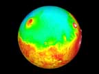 |
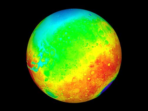
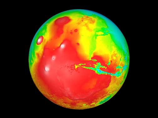
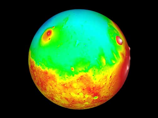
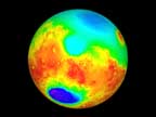
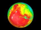
| Images above represent 90 degree 3D global views of Mars.
Click on each globe for a larger view. High Resolution web sites identified at
end of story. |
"This incredible database means that we now know the topography of Mars better than
many continental regions on Earth," said Dr. Carl Pilcher, Science Director for Solar
System Exploration at NASA Headquarters, Washington, DC. "The data will serve as a
basic reference book for Mars scientists for many years, and should inspire a variety of
new insights about the planet's geologic history and the ways that water has flowed across
its surface during the past four billion years."
"The full range of topography on Mars is about 19 miles (30 kilometers), one and a
half times the range of elevations found on Earth," noted Dr. David Smith of NASA's
Goddard Space Flight Center, Greenbelt, MD, the principal investigator for MOLA and lead
author of a study to be published in the May 28, 1999, issue of Science.
"The most curious aspect of the topographic map is the striking difference between
the planet's low, smooth Northern Hemisphere and the heavily cratered Southern
Hemisphere," which sits, on average, about three miles (five kilometers) higher than
the north, Smith added. The MOLA data show that the Northern Hemisphere depression is
distinctly not circular, and suggest that it was shaped by internal geologic processes
during the earliest stages of martian evolution.
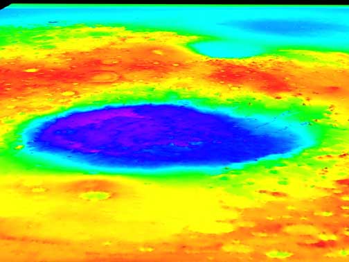
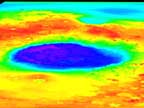 The massive Hellas impact basin in the Southern Hemisphere is another
striking feature of the map. Nearly six miles (nine kilometers) deep and 1,300 miles
(2,100 kilometers) across, the basin is surrounded by a ring of material that rises 1.25
miles (about two kilometers) above the surroundings and stretches out to 2,500 miles
(4,000 kilometers) from the basin center. The massive Hellas impact basin in the Southern Hemisphere is another
striking feature of the map. Nearly six miles (nine kilometers) deep and 1,300 miles
(2,100 kilometers) across, the basin is surrounded by a ring of material that rises 1.25
miles (about two kilometers) above the surroundings and stretches out to 2,500 miles
(4,000 kilometers) from the basin center.
This ring of material, likely thrown out of the basin during the impact of an asteroid,
has a volume equivalent to a two-mile (3.5-kilometer) thick layer spread over the
continental United States, and it contributes significantly to the high topography in the
Southern Hemisphere.
The difference in elevation between the hemispheres results in a slope from the South Pole
to North Pole that was the major influence on the global-scale flow of water early in
martian history. Scientific models of watersheds using the new elevation map show that the
Northern Hemisphere lowlands would have drained three-quarters of the martian surface.
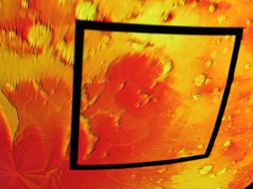
On a more regional scale, the new data show that the eastern part of the vast Valles
Marineris canyon slopes away from nearby outflow channels, with part of it lying a
half-mile (about one kilometer) below the level of the outflow channels.
"While water flowed south to north in general, the data clearly reveal the localized
areas where water may have once formed ponds, " explained Dr. Maria Zuber of the
Massachusetts Institute of Technology, Cambridge, MA, and Goddard.
The amount of water on Mars can be estimated using the new data about the south polar cap
and information about the North Pole released last year. While the poles appear very
different from each other visually, they show a striking similarity in elevation profiles.
Based on recent understanding of the North Pole, this suggests that the South Pole has a
significant water ice component, in addition to carbon dioxide ice.
The upper limit on the present amount of water on the martian surface is 800,000 to 1.2
million cubic miles (3.2 to 4.7 million cubic kilometers), or about 1.5 times the amount
of ice covering Greenland. If both caps are composed completely of water, the combined
volumes are equivalent to a global layer 66 to 100 feet (22 to 33 meters) deep, about
one-third the minimum volume of a proposed ancient ocean on Mars.
During the ongoing Mars Global Surveyor mission, the MOLA instrument is collecting about
900,000 measurements of elevation every day. These data will further improve the global
model, help engineers assess the area where NASA's Mars Polar
Lander mission will set down on Dec. 3, and aid the selection of future landing sites.
MOLA was designed and built by the Laser Remote Sensing Branch of the Laboratory for
Terrestrial Physics at Goddard. The Mars Global Surveyor mission is managed for NASA's
Office of Space Science, engineers assess the area where NASA's Mars Polar
Lander mission will set down on Dec. 3, and aid the selection of future landing sites.
MOLA was designed and built by the Laser Remote Sensing Branch of the Laboratory for
Terrestrial Physics at Goddard. The Mars Global Surveyor mission is managed for NASA's
Office of Space Science,
Washington, DC, by the Jet Propulsion Laboratory, Pasadena, CA, a division of the
California Institute of Technology.
More details about the MOLA instrument and science investigation can be found
at:
http://ltpwww.gsfc.nasa.gov/tharsis/mola.html
Hi-Resolution Images can be found at:
index_hires.html
NASA Press Release at:
|